Mt. Brewer climb, July 22-26, 2003
Here is the story of the hike from preliminary stuff to the story of the hike afterwards
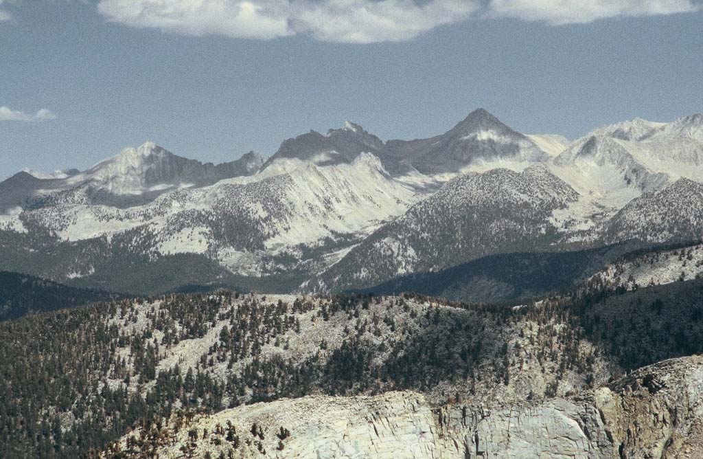
Mt. Brewer taken by Mike from Mt. Silliman in 2002
Mt. Brewer taken by Mike from Mt. Silliman in 2002
(Click on most images to get larger versions)
The Trip Report
The Hike
History
People
Links
Wilderness Permit
Maps
Photo Essay
Geology
Cartoons
Back to our Brewer-trips overview page
So the trip was a great success. You can't beat hiking among mountains and following creeks for five days with loved ones. Maurie was a champ; we ended up hiking the entire way out the last day and she did the 14 miles just fine. That's three more miles than she has years
Click here to see the photo essay of the trip.
Wayne wants to get plenty used to the altitude so he will drive up a few days early and car-camp at Lodgepole, south of our roadhead.
My friends Carol and Chris took their girls up to East Lake 5-6 years ago. A gorgeous area, but a strenuous hike up a steep incline at the upper end of East Canyon (?) just below the lake. Goes through a beautiful Red Fir forest, however, at the lower end of the canyon.
Brewer, King, James Gardner, and Richard Cotter climbed an 11,188-foot peak to get a reconnaissance view to the east. They named that peak Mt. Silliman. Last year, Wayne, Justin, and I climbed Mt. Silliman and share Brewer's vantage point. View our climb story from our Silliman trip.
From Silliman, Brewer's group observed the high country in general and a particularly high peak in particular. They thought it might be the highest point in the Sierra and with that in mind, set off to climb it. When Brewer and Charles Hoffmann got there, they saw farther off to the east, even higher peaks whereupon Brewer may have said something to the effect of "oh rats!" He is said to have said "Such a landscape!" He also may have indicated to King back at camp that "you can't get there from here" whereupon King said something like "...I'm leaving in the morning." The peak they climbed, though not the highest in the Sierra, is named Mt. Brewer now (13,570'). So when Wayne, Justin, and I were on Silliman looking at Brewer, we wanted to continue to follow the 1864 expedition and climb Brewer next - hence this trip.
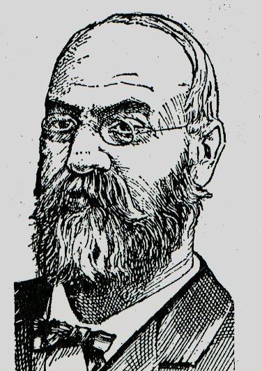
What was that higher peak they saw? Well, it was, as yet, unclimbed and unnamed. King and Cotter set off to climb it and got forced north due to weather so they climbed Mt. Tyndall instead (14,018'), naming it after John Tyndall, the Irish scientist and mountaineer. I had formerly misidentified Professor Tyndall as "English" but happily I received a correction from a fellow in Ireland named Denis O'Brien. He found this Web site and emailed: "A correction for you're website. John Tyndall was as British and as English as I am. He is in fact Irish. He was born in a little Village called Leighlinbridge County Carlow in Ireland and was educated in Ireland. He worked on the Irish railway system and then became a teacher before moving to England to become a professor. Just a small detail but us small fry countries have to claim all the fame we can. "
King tried to climb that highest peak again in 1871, but ended up on the wrong peak by mistake. After claiming to have made it, it turned out that he climbed Mt. Langley instead (14,042') now named after Samuel Langley, the astronomer and physicist.
That highest peak was finally climbed by three fisherman who, I guess, were not catching anything and decided to do something else that day. Charles D. Begole, Albert H. Johnson, and John Lucas made the first ascent on August 18, 1873 and, since they got their first, the local townsfolks named it Fishermans Peak (14,496'). Well, as the peak was discovered, if not climbed, in 1864 by Brewer and Hoffmann, they named it after their leader, Josiah Whitney. That is the name that stuck but if you hear me mention Fishermans Peak, you'll know what I mean.
King finally summited Mt. Whitney on September 19, 1873; he made the forth ascent. John Muir pioneered the Mountaineers Route up Whitney on October 21 that same year.
Now don't get me wrong; Clarence King was really quite a good guy. My friend Jim tells me that he was the first to recognize glaciation as taking place in North America when he observed what he named the Whitney Glacier on Mt. Shasta in 1870. He led the geological survey Fortieth Parallel expedition (1867-1878) and went on to organize and become the first Director of the U.S. Geological Survey.
Bill Finch's site - a comprehensive collection of Kings Canyon and Sequoia trip reports and links
Sequoia/Kings Canyon National Park, NPS home page
Bears, food storage, and how to protect bears from us
The dates you wish to begin and end your trip.
The trailhead where you will be entering and exiting the park. (Send alternate entry points and/or dates to avoid delays in getting reservations)
Method of travel (foot, horse, ski, snowshoe)
The number of people in your party (maximum is 15, except in Redwood Canyon where it is 10).
The number of pack and saddle stock in your party, if applicable (maximum is 20).
Your best estimate of where you will camp and the number of nights in each location.
The name of your organization or group (if applicable).
Your name, address, and phone number.
As we drove to the roadhead up Kings Canyon, we passed the Granite of North Mountain, a septum of pelitic hornfels and schist, and the Granodiorite of Long Peak but we never walked in those units. On the hike, when we got to Junction Meadow and turned up East Creek, we were just shy of a septum of Jurassic or Triassic metavolcanic rocks that separate the Paradise Granodiorite from the Bullfrog Pluton. The Paradise Granodiorite is one of the outer parts of the Mount Whitney Intrusive Suite with the inner parts being the Whitney Granodiorite and granite porphyry dikes and sills including the Golden Bear dike. We were fewer than four miles from these units. When we go back and climb Mt. Brewer some other year, we plan to go up Sphinx Creek and do the west approach for a change of scenery. We will then be within a couple miles of the Sugarloaf Pluton which is the outer part of the Mount Whitney Intrusive Suite.
I got this information from Jim Moore's Lone Pine Peak (USGS I-2617, 2000), Marion Peak (USGS GQ-1399, 1978) Mount Pinchot (USGS B-1130, 1963), Mount Whitney (USGS GQ-1545, 1981), and Triple Divide Peak (USGS GQ-1636, 1987) quadrangles.
Date created: February 10, 2003
The Hike
This is a five-day, four-night backpacking and mountaineering trip to the central Sierra Nevada's Kings Canyon National Park. We will start at the end of the road in Kings Canyon, hike up Bubbs Creek to East Creek, and make a base camp at East Lake. From there, some or all of us will climb Mt. Brewer.
History
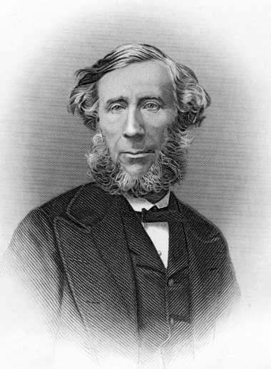
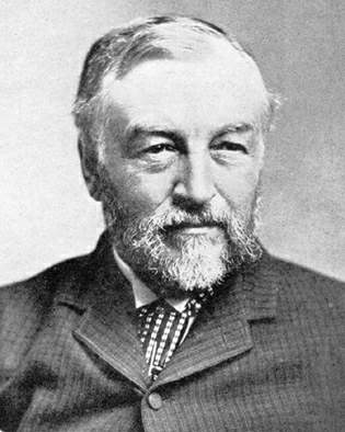
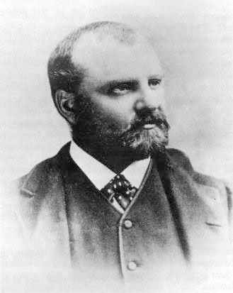
The idea for this trip began last year. Well, OK; it began about five years ago when my friend Jim Moore was writing his book for Stanford Press on the Sierra and he told me the story of William Brewer. Brewer was working for Josiah Whitney and needed an help for his 1864 exploration of the Sierra Nevada. He contacted his major professor at Yale, Benjamin Silliman who recommended Clarence King.
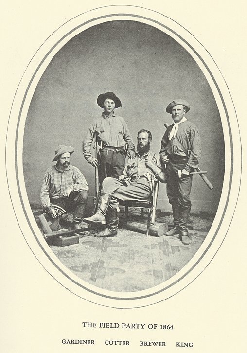
The field party of 1964
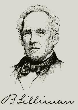

Benjamin Silliman; Mt. Silliman taken by Mike with Wayne and Justin

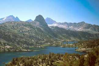
William Brewer; Mt. Brewer (pyramid on left skyline) taken by Justin from Mt. Silliman

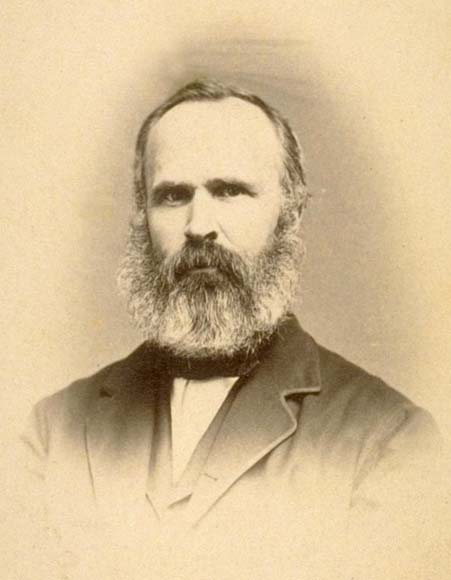
John Tyndall; Mt. Tyndall taken by Mike and Anna from Mt. Williamson

Samuel Langley; Mt. Langley taken by Mike from Sky Blue Lake

Josiah Whitney; Fishermans Peak taken by Mike from Mt. Muir

John Muir; Mt. Muir (14,012') taken by Mike from below Fishermans Peak
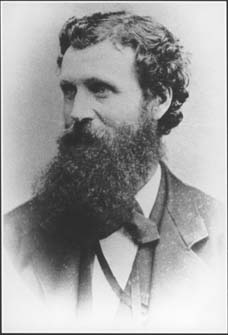
Clarence King; Mt. Clarence King (12,905') in the background behind Fin Dome; that's Mt. Cotter on the left. - Photo © Bob Carney
People
We have half a dozen people going on this trip:
 Wayne Penn
 Jon Penn
 Justin Rolfe
 Deanna Buhl
 Maurie
 and me, Mike Diggles
Links
Reading:
Wilderness Permit
On March 1, 2003, the first day the National Park Service accepts wilderness-permit reservations for this area, we send in this info:
Tuesday, July 22, 2003
Roads End
Foot
15
0
1. Charlotte Creek confluence with Bubbs Creek
2. East Lake
3. East Lake
4. Charlotte Creek confluence with Bubbs Creek
(private trip)
Michael F. Diggles
154 Rutherford Ave.
Redwood City, CA 94061-3500
650-329-5404
mdiggles@usgs.gov
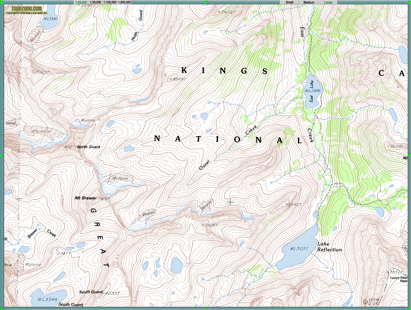
Maps
Click on the map to get a larger version
Photo Essay
CLICK HERE to see the photo album. There are 100 photos in this collection and I thought I had better put them in a separate page.
Geology
The entire hike was on the same rock unit: The Late Cretaceous Paradise Granodiorite. This is a porphyritic granodiorite and granite that contains potassium feldspar phenocrysts 1 to 3 cm long that are characterized by abundant, zonally arranged inclusions of biotite and hornblende. It has a biotite K-Ar age 78 Ma and a hornblende K-Ar age 84 Ma (Evernden and Kistler, USGS P-623, 1970). It has Pb-U ages 86 to 83 Ma (Chen and Moore, JGR, 1982). It contains an average of about 70 weight percent SiO2.
Cartoons


Go to Mike Diggles' home page
Email Mike (mike@diggles.com).
Date modified: September 23, 2012
The URL of this Web site is http://www.diggles.com/brewer/brewer_2003/index.html