
ByJ.G. Liou and L.Y. Hsiao
Dept. of Geological and Environmental Sciences
Stanford University, Stanford, CA 94305
(Oct. 1st, 1999)
1999
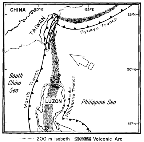
Figure 1 (after Ernst et al., 1985). Regional plate tectonic setting of Taiwan at the intersection of Ryukyu and Manila trenches with the continental margin of Asia, largely after Hamilton (1979). The arrow indicates the approximate motion of the Philippine Sea plate relative to Asia (7 cm/yr. [3 in./year] according to Seno, 1977). The Philippine Sea plate is descending obliquely beneath the Ryukyu arc but is being thrust over the South China Sea and Chinese continental margin. Thus, relative to the Asiatic plate, the Manila trench is moving concomitantly westward with time. The Philippine trench appears to be propagating northward (Lewis and Hayes, 1983).
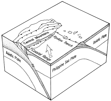
Figure 2 (after Ernst et al., 1985). Schematic diagram showing present plate tectonic configuration of Taiwan. Whereas the convergent plate junction located seaward from the Ryukyu arc is a well-defined linear feature, the eastward underflow of the Asiatic plate beneath the Philippine Sea and surmounting Coastal Range (the Luzon calc-alkaline arc) is being choked off because of accumulation of imbricated passive margin wedge (+ forarc basin) and distributory thrust fault system present throughout the main part of Taiwan. The Longitudinal Valley marks the juxtaposition of exotic Coastal Range (including its forarc basin) with the miogeoclinal wedge and its Asiatic basement; a minimum of 150 km (90 mi.) left-lateral slip has taken place along this strike-slip fault system since the Pliocene onset of the collisional event (Tsai, 1978).
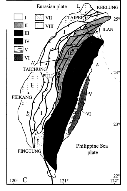
Figure 3. Major tectonic units of Taiwan (after Lu et al., 1998)
Units (b) and (c) represent the active fold-and-thrust belt of western Taiwan. These Cenozoic strata represent continental shelf deposits, and are comprised of sandstone, quartzite, slate, argillite, and tuff of Oligocene to Pliocene age. They are typified by imbricate thrusts and folds with west vengeance, reflecting up to 160-200 km horizontal shortening (Suppe, 1980). The Backbone Range slate is a huge mass of dark gray phyllite intercalated with sandstone and limestone blocks of Eocene to Miocene age, and igneous rocks such as pillow lava, diorite, gabbro, minor andesite, diabase and pyroclastic products. Informally known in aggregate as the slate series, this nonturbiditic sedimentary prism consists of continental shelf to slope deposits.
The Paleozoic/Mesozoic basement is composed of three lithologic units. The first has been interpreted as a Mesozoic melange complex marking an ancient accretionary wedge or suture zone. The second consists exclusively of massive marbles dated radiometrically as Paleozoic. The third unit consists of metamorphosed Cretaceous granitoid rocks.
Eastward across the tectonic boundary along the Longitudinal Valley, which is a zone of modern intraorogenic left-lateral strike-slip vertical faults, lies the Coastal Range. It consists of Miocene Luzon arc calc-alkaline volcanics and associated sediments, forearc-basin flysch deposits, and the trench-basin Lichi melange enclosing abundant olistostromal debris including the fragmented and dispersed East Taiwan Ophiolite.
The mechanism of thin-skinned tectonics has been used to explain the recognized fold-and-thrusting patterns in western Taiwan (Ho, 1986). According to this model, thrusting was relatively shallow and confined to the cover sequence above the basement, resulting thin-skinned deformation. Related to these decollements, most thrust faults are east-dipping high-angle reverse faults. However, recent studies in many parts of the fold-and-thrust belt of south-central Taiwan demonstrate that some basins (e.g., the Puli Basin; see Figure 3 for the locality) developed within extended terranes; evidently, thrusting took place through reactivation of extensional faults and resulted in the formation of complicated thrust geometries. Hence, reactivated normal faults may play a significant role in the compressive deformation in the fold-and-thrust belt of western Taiwan (Suppe, 1986; Chang et al., 1996). This mechanism has been considered to represent inversion tectonics.
Because of the oblique convergence and the indentation of the Philippine Sea plate, the fold-and-thrust belt of the majority of the Western Foothills developed a combination of contractional, transcurrent, rotational, and extensional deformation features, which resulted in thrusting, strike-slip and normal faulting (Liu et al., 1998). To the north, however, this fold-and-thrust belt is subjected to crustal stretching and rifting due to the flip of subduction of the Philippine Sea Plate (Teng, 1996).
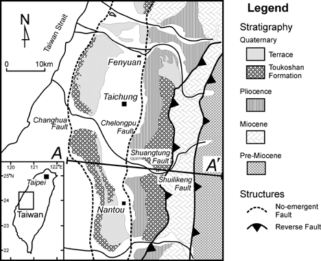
Figure 4. Schematic map showing the traces and general geology of the 9-21-99 earthquake region (modified after Ho, 1986)
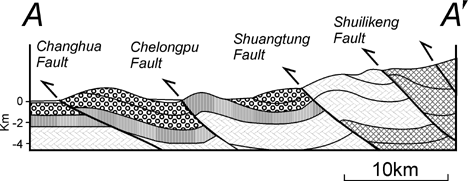
Figure 5. Schematic E-W cross section showing series E-dipping thrusts in the fold-and-thrust belt of the Western Foothill of Taiwan (modified after Lee et al., 1996)
On the other hand, some high-angle reverse faults in central Taiwan have been recognized to be associated with large-magnitude earthquakes [see Report #5 of this Series (Bonilla, 1999)]. This includes the earthquake at Chihhu and Tuntzuchio in 1935 (7.0 Richter magnitude) described by Bonilla (1975). Such high-angle detachment west-dipping reverse faults may have resulted from the reactivation of pre-existing normal faults in the Western Foothills.
Because of the limited time, we did not cover some information from many recent papers from Taiwan. The following references summarize the general tectonics and regional geology of the area. For a review of neotectonics of the Taiwan mountain belt, see Liu et al. (1998), and for the general geology of the epicenter of the 9-21-99 Chi-Chi earthquake, see Ho (1986, p. 112-113). Please also refer to the contents of the following web sites for detailed information about the Chi-chi Earthquake:
http://www.sinica.edu.tw/~jclee/921chichi_main_ch.htm (In Chinese);
http://www-ses.gep.ncu.edu.tw (In Chinese);
Bonilla, M. G., 1999. A note on historic and Quaternary faults in western Taiwan, U. S. Geological Survey, Open-File Report 99-447, 5 pp.
Chang, Y. L., Lee, C. I., Lin, C. W., Hsu, C. H., Mao, E. W., 1996. Inversion tectonics in the fold-trust belt of the foothills of the Chiayi-Tainan area, southwestern Taiwan. Petroleum Geology of Taiwan, no. 30, p. 163-176.
Ernst, W.G., C.S. Ho, and J.G. Liou, 1985, Rifting, drifting and crustal accretion in the Taiwan sector of the Asian continental margin. in Tectonostratigraphic Terranes of the Circum-Pacific Region (ed. David Howell), Circum Pacific Energy & Mineral Resource, Earth Sci. Series, no.1, p. 375-390.
Ho, C. S., 1986. An Introduction to the Geology of Taiwan: Explanatory text of the Geologic Map of Taiwan. Central Geological Survey, Taipei, Taiwan, RO China, 192 pp.
Lee, J.C., Lu, C.Y., Chu, H.T., Delcaillau, B., Angelier, J., and Deffontaines, B., 1996. Active deformation and paleostress analysis in the Pakua anticline area, western Taiwan: TAO, v. 7, n. 4, 431-446.
Lu, C. Y., Yu, S. B., and C. H. T., 1998. Neotectonics of the Taiwan Mountain Belt. in Flower et al., (eds) Mantle Dynamics and Plate Interactions in East Asia. American Geophysical Union, Geodynamic series, v. 27, p. 301-315.
Teng, L. S., 1996. Extensional collapse of the northern Taiwan mountain belt. Geology, v. 24, p. 949-952.
Suppe, J., 1981. Mechanics of mountain building and metamorphism in Taiwan. Memoir Geol. Soc. China, no. 7, p. 67-8
Suppe, J., 1986. Reactivated normal faults in the western Taiwan fold-and-thrust belt. Memoir Geol. Soc. China, no. 7, p. 187-220
The URL of this page is http://www.diggles.com/chi-chi/chi-chi4.html
Date created: 10/02/1999
Last modified: 01/15/2002