 Web page hosted by the U.S. Geological Survey
Web page hosted by the U.S. Geological Survey

This will be the 320th meeting since 1954.

Location: Stanford University
Anyone wishing to attend the tour and lecture only is welcome at no cost.
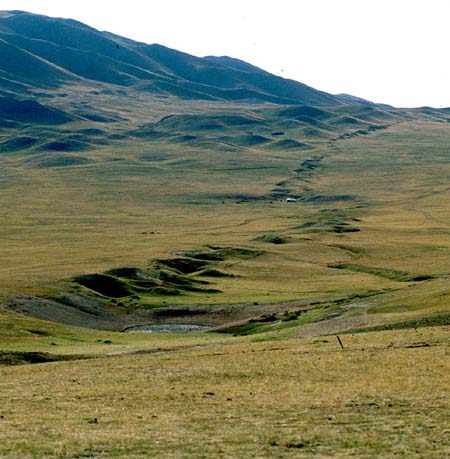
The 1905 Bulnay earthquake, along with the 1957 Gobi-Altay (Mongolia), and 1811-1812 New Madrid earthquakes are geometrically complex ruptures (strike-slip, reverse, normal faulting) that release strain in a large volume of crust (100s of km long, 10s of km across) as sequences that can be weeks in duration. This type of faulting may characterize continental interiors where rates of deformation are low and faults have relatively small amounts of long-term offset.
Suzanne Hecker
Project geologist with the Earthquake Hazards Team of the U.S. Geological Survey in Menlo Park, CA. Received B.S. in geology in 1982 from Bucknell University; received M.S. in geosciences in 1985 from the University of Arizona. For my thesis, I researched the timing of paleoearthquakes within the Central Nevada Seismic Belt. I worked for the Utah Geological Survey until 1991; there I compiled a comprehensive database and review paper on the Quaternary tectonics of Utah. Since joining the U.S.G.S. in 1991, I have applied my experience in data synthesis to developing (along with Dan Ponti and others) a digital fault database for the Los Angeles region, and to compiling a worldwide fault-slip database for use in considering event-to-event variability in earthquake sizes on faults. I also have developed a method of systematically evaluating uncertainties in paleoseismic study results- in order to provide information on the reliability of data used in seismic hazard analyses. My work also involves paleoseismic investigation of faults in the Bay area, in southern California-and, occasionally, in such far-flung places as Mongolia and Kenya.
David Schwartz, earthquake geologist/paleoseismologis,t Western Earthquake Hazards Team, USGS, Menlo Park, Calif.
I received my BA and MA in geology from Queens College of the City University of NY (1966, 1973). In 1976 I received my PhD in geology from the State University of NY at Binghamton. My dissertation was on the geological development of Central America, where I spent ten months in eastern Guatemala mapping metamorphic rocks and active faults . In 1973 I joined Woodward-Clyde Consultants in Oakland/San Francisco. My first job was locating active faults along the route of the trans-Alaska pipeline and was followed by eight months in Managua, Nicaragua doing geologic work for the reconstruction of that city after the devastating 1972 earthquake. I remained at Woodward-Clyde until 1985, participating in earthquake hazard studies for critical facilities, major dams, and nuclear power plants throughout the western US and other parts of the world (Peru, Egypt, Japan). During this period the work of our group, particularly along the Wasatch fault in Utah, pushed forward the newly developing fields of earthquake geology and paleoseismology. I helped develop new methods to quantify the behavior of faults in space and time, particularly those that had not yet produced their earthquake, and to incorporate geological parameters such as earthquake recurrence intervals and fault slip rates into seismic hazard analysis. My major contribution in this area is the characteristic earthquake recurrence model, which has become a cornerstone of many seismic hazard analyses.
In 1985 I was offered a position by the USGS that I couldn't refuse--less money but a free hand in research! Since then I've led earthquake geology and paleoseismology studies along surface ruptures from large magnitude historical earthquakes. These have included studies of: the great 1906 and 1857 earthquakes on the San Andreas fault in northern and southern California; the M7.5 1976 Motagua fault, Guatemala earthquake; the M7.0 1980 Irpinia fault, Italy earthquake; the M6.9 1983 Borah Peak fault, Idaho earthquake; the M7.3 1992 Landers fault, CA earthquake and, most recently, the M8 1957 Gobi-Altay fault, Mongolia earthquake. The study of these historical ruptures provides critical calibration of techniques used to quantify earthquake recurrence and hazards. At present I am the Northern California coordinator for the National Earthquake Hazards Reduction Program and Chief of the San Francisco Bay Area Earthquake Hazards megaproject. I've been a member of the Working Group on California Earthquake Probabilities that issued the 30-year earthquake forecasts for northern and southern California in 1988, 1990, and 1995, and I am heading the new Bay Area probability study, which will be available in 1999. I live in Danville, CA , about two miles from the Calaveras fault, with my wife and two children and cross the Hayward and Calaveras faults twice a day on my way to and from the office.
Reservations: The preferred way to make reservations is simply to email Willie Lee at lee@andreas.wr.usgs.gov, tell him you will attend, commit to pay, and bring your payment to the meeting. A check made to "PGS" is preferred.
If you want to pay in advance:
Stanford faculty and students: Please make dinner reservations by Friday, March 5. Contact Dr. Juhn Liou via his mailbox (and leave check), Geological and Environmental Sciences Office, Mitchell Bldg. (Rm. 138). Make checks out to "PGS."
All others, including faculty and students from other Bay Area universities and colleges and USGS: Please make dinner reservations by Friday, March 5. Contact Willie Lee, at USGS, MS-977, 345 Middlefield Rd., Menlo Park, CA 94025, phone 650-329-4781. Send check made out to "PGS" to Willie.
Dinner is $23.00. Includes wine (5:30 to 6:15 PM.), dinner (6:15-7:30 PM.), tax, and tip. Note: PGS does not make revenue on this price.
For students from all universities and colleges, the dinner, including the social half-hour, is $5.00 and is partially subsidized thanks to the Associates of School of Earth Sciences, Stanford University (Note, no-show reservations owe the full price).
Dues for Academic Year 1998-99 ($5.00; beginning Fall, 1999 they will be $10) should be sent to Willie Lee, USGS, MS-977, 345 Middlefield Rd., Menlo Park, CA 94025. Willie's phone: 650-329-4781.
Officers: Gary Ernst, President; Mike Diggles, Vice President; Vicki Langenheim, Secretary; Willie Lee, Treasurer

Date created: 02/18/1999
Last modified: 03/08/1999
Created by: Mike Diggles, Vice President, PGS.