Location: Stanford University
see Map showing Mitchell
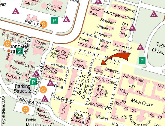
Map showing Bloch
This will be the 366th meeting since 1954.
•Vertical tectonic deformation over an area of 140,000+ km2,...•Uplift to 11.3 m, •Subsidence to 2.3 m, •Surface thrust faults with slip to 7.9 m, •Megathrust slip to 23+ m, •Destructive tsunamis generated by subaqueous landslides and sea floor uplift, • •Interseismic deformation, •A 5,600-year paleoseismic record of 8 subduction earthquakes, and •lots more?
Forty years ago, on March 27, 1964, Alaska was rocked by the world's second largest instrumentally recorded earthquake (M 9.2) caused by rupture of an 800-km-long megathrust segment at the eastern end of the Aleutian arc. The 1964 earthquake occurred at a particularly critical point during the revolution in the earth sciences that was fostered by the concepts of sea floor spreading and its implications--which subsequently evolved into the global plate tectonics paradigm. In this paper I will first briefly summarize the general state of knowledge up to 1964 concerning active deformation in tectonic arcs. I will then review relevant data from the 1964 event bearing on interpretions of the 1964 earthquake mechanism and tectonics of the eastern Aleutian arc.
Benioff published his classic paper on dipping circum-Pacific seismic zones (including the Aleutian Arc) in 1954. In Alaska a decade later, little was known about onshore seismicity, there were only two permanent seismographs, and the methodology for deducing mechanisms from seismic records was still in its infancy. Dietz and Hess in 1961 and 1962 suggested that oceanic trenches and arcs in general probably marked zones of crustal convergence. Onshore geologic mapping at reconnaissance scale was complete for most of the southern Alaska margin and sparse marine geophysical data were available for the Gulf of Alaska and Aleutian Arc. In 1962, a remarkably insightful paper by Robert Coats of the USGS proposed a model for underthrusting of oceanic crust beneath the Aleutian arc that is barely distinguishable from present-day models (Figure 1). It incorporated explanations for (1) a trench marked by convergence and underthrusting of oceanic crust, (2) a confusing pattern of earthquake mechanisms, (3) accretionary assemblages, and (4) a subparallel dominantly andesitic volcanic arc. Unfortunately, Coats' paper was published only in a relatively obscure journal and was generally unread or ignored. As early as 1963 some marine geophysicists recognized that oceanic ridges and subparallel sea floor magnetic stripes indicated ridge spreading and extension of oceanic crust. During the same time period, however, marine researchers in the far more complex convergent margins of the world--including Alaska--could not find any evidence for the postulated compression at the trenches, and many proposed that trenches were actually zones of extension. Additional arguments against arc convergence involved supposed counterclockwise rotation of the Pacific Ocean basin (Hodgson, 1957) and a theory that Benioff zone earthquakes were caused by phase transitions, rather than faults (Evison, 1963).
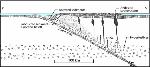
Figure 1. Cross section through crust and upper mantle of a generalized arc showing suggested mechanism for development of andesitic rocks through addition of water and hyperfusible materials from eugeosynclinal deposits to eruptible basaltic material in the mantle. R.R. Coats, 1962.
The great 1964 Alaska earthquake resulted in the largest area of tectonic deformation in a single event that has ever been documented. The Alaskan earthquake involved rupture and seaward thrusting of a segment of the eastern Aleutian megathrust 800 km long and from 200-250 km wide down dip, as well as slip on subsidiary intraplate surface thrust faults. The horizontal component of slip on the megathrust and subsidiary thrusts averaged about 9 m and may locally be 23 m or more; coseismic fault displacements resulted in sudden changes in elevation ranging from 2 m subsidence to 11 m uplift (Figure 2). Deformation included an onshore and offshore area of Alaska about equal to the area of Oregon and Washington combined. Tsunamis generated by both regional vertical seafloor displacements offshore and local earthquake-triggered submarine slides along the coast resulted in most of the casualties and property damage. Combined seismic, geologic, and geodetic data for the 1964 Alaska earthquake provided direct evidence for major convergence and thrust faulting in an arc environment. Nevertheless, arguments about the mechanisms of great arc earthquakes and the nature of deformation within the arcs were to continue, with gradually diminishing intensity, for several years afterwards.
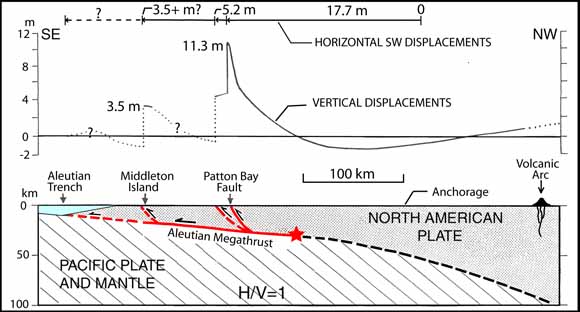
Figure 2. Profile and section of coseismic deformation associated with the 1964 Alaska earthquake across the Aleutian arc (oriented NW-SE through Middleton and Montague Islands). Profile of horizontal and vertical components of coseismic slip (above) and inferred slip partitioning between the megathrust and intraplate faults (below). From Plafker (1965, 1967; 1972).

George Plafker
George Plafker received his B.S. (Geology) from Brooklyn College in 1949; his M.S. (Geology) from U.C. Berkeley in 1956; and his Ph.D. (Geology and Geophysics) from Stanford University, 1972.
Positions he has held include Engineering Geologist, U.S. Army Corps of Engineers, 1949-1950; Geologist & Research Geologist, U.S. Geological Survey, 1951-1956, 1962-1995; Petroleum Geologist, Chevron, 1956-1961; Consulting Engineering Geologist, 1995-present.
His considerable contributions to Earth science include:
Reservations: The preferred way to make reservations is simply to email Janice Sellers at janice@seismosoc.org by Nov. 5, tell her you will attend, commit to pay, and bring your payment to the meeting. Janice always emails a confirmation; if you don't get one, assume email crashed yet again and email her a second time. A check made to "PGS" is preferred, payable at the meeting.
If you want to pay in advance:
Stanford faculty and students: Please make dinner reservations by Nov. 5. Contact Dr. Juhn Liou via his mailbox (and leave check), Geological and Environmental Sciences Office, Geocorner - Bldg. 320 (Rm. 118). Make checks out to "PGS."
All others, including faculty and students from other Bay Area universities and colleges and USGS: Please make dinner reservations by Nov. 5. Contact Janice Sellers, at Seismological Society of America, 201 Plaza Professional Building, El Cerrito, CA 94530, phone (510) 559-1780. Send check made out to "PGS" to Janice.
Dinner is $30.00. Includes wine (5:30 to 6:15 PM.), dinner (6:15-7:30 PM.), tax, and tip.
For students from all universities and colleges, the dinner, including the social 3/4-hour, is $5.00 and is partially subsidized thanks to the School of Earth Sciences, Stanford University (Note, no-show reservations owe the full price).
Doris, whose wonderful crew prepares our meals, asked that we let you know that people who are late RSVP'ing and people who show up without a reservation will be welcome but that they will be eating on paper plates with plastic utensils (food supply permitting).
Dues for Academic Year 2004-2005 ($10.00) should be sent to Janice Sellers, Seismological Society of America, 201 Plaza Professional Building, El Cerrito, CA 94530. Janice's phone: (510) 559-1780.
Officers: Cheryl Smith, President; Mike Diggles, Vice President; Vicki Langenheim, Secretary; Janice Sellers, Treasurer; Adina Paytan, Field-Trip Czarina
Date created: 10/19/2004
Last modified: 12/01/2004
Created by: Mike Diggles, Vice President, PGS.