Presents
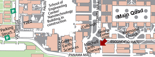
Location: Stanford University
This will be the 436th meeting since 1954
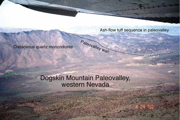
Dogskin Mountain Paleovalley
The distribution of Cenozoic ash-flow tuffs in the Great Basin and the Sierra Nevada demonstrates that the region was an erosional highland, commonly called the Nevadaplano, that was drained by major west- and east-trending rivers, with a north-south paleodivide through eastern Nevada. Mostly Oligocene (34–23 Ma) tuffs in central Nevada can be correlated from source calderas in the central Nevada caldera belt as far west as the western foothills of the Sierra Nevada. Present-day distances from source to distal, primary tuff deposits are as much as ~295 km. Corrected for extension, original flow distances were as much as ~200 km. The tuffs flowed, were deposited, and are preserved primarily in deep (as much as 1.2 km) but wide (8–10 km) paleovalleys. The tuffs were able to flow these great distances because they were channelized, did not disperse, and did not mix with air as much as would tuffs that spread more radially. The paleovalleys held major rivers that drained the Nevadaplano either westward to the Pacific Ocean in what is now the Great Valley or eastward to the Uinta Basin. The distribution of the tuffs and continuity of paleovalleys demonstrates that (1) the Basin and Range–Sierra Nevada structural and topographic boundary did not exist before 23 Ma; (2) the Sierra Nevada was a lower, western ramp to the Nevadaplano; and (3) any faulting before 23 Ma in western Nevada, including in what is now the Walker Lane, was insufficient to disrupt the paleodrainages.
Similarly, the distribution of tuffs and paleovalleys in northeastern Nevada has significant implications for the timing and amount of uplift and extension in the Ruby Mountains metamorphic core complex. From geobarometry and thermochronology on deep-seated rocks, the core complex has long been interpreted to have undergone as much as 30 km of exhumation between ~80 and 22 Ma, with major exhumation/extension in the Eocene. However, Eocene (45-40 Ma) tuffs and one particularly widespread 29 Ma tuff can be correlated across what is now the core complex, which suggests rivers crossed the core complex area until at least 29 Ma. Eocene rocks in northeastern Nevada were everywhere deposited on uppermost crustal rocks, either upper plate rocks of the Roberts Mountain allochthon west of the Ruby Mountains or Triassic to Pennsylvanian-Permian to rarely as deep as Mississippian rocks farther east. A small angular unconformity between ~40 and 38 Ma rocks in northeastern Nevada suggests minor extension at that time contemporaneous with major magmatism. All Eocene stratigraphic-structural relief can be attributed to Mesozoic folds, the episode of minor extension, and to as much as ~1 km of erosion in paleovalleys. The combined data preclude major extensional uplift and exposure of deeper rocks at least through the Eocene and probably not before 29 Ma. The contrast between interpretations about Cenozoic extension based on lower to middle crustal rocks and on uppermost crustal rocks is a continuing puzzle.
(A related paper in GSA’s Geosphere)
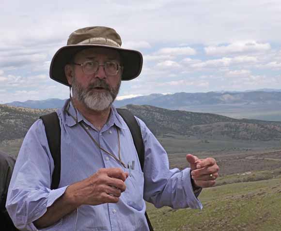
Chris Henry
Chris is a research geologist with the Nevada Bureau of Mines and Geology, a research part of the University of Nevada Reno and the Nevada state geological survey. He’s fundamentally a geologic mapper and works on magmatism, tectonics, and ore deposits, especially in the Great Basin. He’s been at NBMG since 1993, after spending almost 20 years with the Bureau of Economic Geology, a research part of the University of Texas at Austin and the Texas state geological survey. Chris’ faculty page.
Reservations: The preferred way to make reservations is simply to email Mike Diggles at mdiggles@usgs.gov by Dec. 9, tell him you will attend, commit to pay, and bring your payment to the meeting. Mike always emails a confirmation; if you don’t get one, assume email crashed yet again and email him a second time. A check made to “PGS” is preferred, payable at the meeting.
If you want to pay in advance:
Everyone (including Stanford folks now) Please make dinner reservations by Dec. 9. Contact Mike Diggles, at U.S. Geological Survey, 345 Middlefield Road, MS-951 Menlo Park, CA 94025, Tel.: (650) 329-5404. Send check made out to “PGS” to Mike.
Dinner and the social hour is $35.00; this includes $5 that we use to help pay for students who are only $8.00 (also partially subsidized thanks to the School of Earth Sciences, Stanford University (Note, no-show reservations owe the full price).
Doris, whose wonderful crew prepares our meals, asked that we let you know that people who are late RSVPing and people who show up without a reservation will be welcome but that they will be eating on paper plates with plastic utensils (food supply permitting).
Dues for Academic Year 2012-2013 ($10.00) should be sent to Mike Diggles, U.S. Geological Survey, 345 Middlefield Road, MS-951, Menlo Park, CA 94025. Mike’s phone: (650) 329-5404.
Officers: Joe Colgan, President; Mike Diggles, Secretary-Treasurer; Elizabeth Miller, PGS Stanford University Coordinator
Date created: November 24, 2012
Last modified: November 25, 2012
Created by: Mike Diggles, Webmaster-Secretary-Treasurer, PGS.