BOOT 'N BLISTER REUNION TRIP, SEPTEMBER 28, 29, AND 30, 2001
SAPPHIRE AND EMERALD LAKES (STUART FORK, TRINITY RIVER) OVERNIGHT BACKPACK
Note: The six-page newsletter I mailed is also available here (3.9 MB) (and in color) as an Adobe Acrobat PDF. This file was created for Adobe Acrobat Reader 5.0 and is a tagged PDF that is accessible to sight-disabled people using assistive technology such as screen readers.
This year, we are planning to go back to the Klamath Mountains and hike up Stuart Fork of the Trinity River to Sapphire and Emerald Lakes. The hike is a bit long but it isn't going to get any shorter and those are wonderful lakes at the top of the canyon. It is about 12 miles one way to the first lake. The roadhead is just past Trinity Alps Resort; you could even book a room for before the hike, after the hike, or both. As this is a long hike and Equinox will have just passed, I wanted to have plenty of daylight so I bumped the date up a bit from Columbus day. Even when we were younger and spry, this was a long hike and more than a few of us have taken off up there and ended up camped at Morris Meadow instead of the lake. We can do that again this time if we like. In fact, an idea that one of the hiking guides suggests is make a base camp at Morris Meadow and take your day pack the five miles up to the lower lake (Emerald) the next morning. This would be a good three-day hike and I encourage anybody who wants to do that to do so. The hike into the upper lake (Sapphire) is quite steep; I recall, if I have my lakes right, a story Ken told of hiking up there with his Afghan hounds and having to lift them up onto the granite shelves that comprise the trail (or was that North Fork Trinity River?).
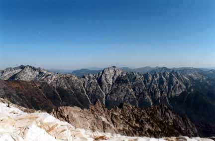
View from the base of Sawtooth Mountain. Caribou Mountain is on the left, Tri-Forest Peak in the Middle, Sapphire is in the valley between Caribou and "Devils Pinnacles" in the middleground. Shasta is directly behind Tri-Forest Peak. Photograph by Marvin Goss.
Base Camp Friday Night
Approximately 13 miles north of Weaverville on Highway 3 (Trinity Center is several miles to the north), the road crosses a bridge at the Stuart Fork arm of Clair Engle reservoir ("Trinity Lake"). Just past the bridge, take the paved road to the left and go up past Trinity Alps Resort. After the resort, the road turns to gravel and goes to Bridge Camp. This is where we plan to have our night-before car camp. It is a total of 3.5 miles from Highway 3. There is a possibility that this small camp may be full so look for Boot 'n Blister signs that may direct you to one of the fee campgrounds back on Highway 3. About seven miles north of the Stuart Fork bridge on Highway 3 a two-mile-long road down the hill to Minersville Campground on the lake. That'll be our fallback "roadhead" camp.

Trailhead
The trailhead is at Bridge Camp. The first mile of the hike, beyond a locked gate, follows a road, actually. This is a bit of private land with public foot access on their road to where the trail begins.
Hike
This trip is about 12 miles one way to the lower lake. The elevation gain is about 3,500', much of it in the last five miles. The trail goes from Cherry Flat and drops down to Stuart Fork, then does a few ups and downs to a new bridge at Deep Creek (new to us; it was put in after a flood in 1983). We pass the Boulder Creek-Alpine Lake junction and the trail follows the old La Grande Ditch. Remember that big hydraulic-mining viewpoint on Highway 299 at Oregon Mountain Summit between Junction City and Weaverville? Well this ditch, in the 1880's, provided water from Emerald Lake to that mine. More creeks come and go: Salt Creek and Deer Creek. Then we get to climb the moraine that used to be a dam forming a lake (a few thousand years ago) but it has since filled in with sediment, drained, and has grass growing on it. Yes, this is Morris Meadow. I like this excerpt from Linkhart and White (1994): "A midsummer evening at Morris Meadow can be truly memorable - offering an exquisite tableau of deer grazing in waist-high grass, backlit by the setting sun reflecting off the multicolored backdrop of Sawtooth Ridge rising 2,000 feet above the forest fringe at the north end of the meadow." This is where it might be nice to camp if the day is getting short and the hike is seeming long. Or it is another five miles up to the lower lake. There is no firewood so bring a stove. The water these days needs to be purified, so bring a pump. There are no trees at Emerald Lake so bring a bear canister. This is true alpine terrain for the Klamath Mountains. If we camp at Emerald, a day-pack trip up to Sapphire the next morning would be nice. It is twice as big as Emerald and is perhaps as deep as 200 feet making it the deepest lake in the Trinities. Swimming is better below this lake as it is the last one in the canyon (except perhaps Mirror Lake up in the cirque above) to warm up and perhaps never gets very warm. There are several peak bagging opportunities in this canyon. Little Granite Peak (8,031'), Tri-Forest Peak (7,670), and, of course, Sawtooth Mountain (8,415') are within range. As you hike up the canyon you also hike up through geologic time. Much of the beginning of the hike is underlain by Stuart Fork Terrane. Here is an excerpt Gary Ernst from the Peninsula Geological Society field guide to Mt. Shasta and the Klamath Mountains (http://www.diggles.com/pgs/). "The Stuart Fork terrane consists of interlayered metapelitic and metabasaltic subunits that structurally underlie the yet older Central Metamorphic belt. Geochronological data indicate that blueschists formed during earliest Mesozoic subduction beneath the North American margin or an offshore arc (Hotz, 1973). The Stuart Fork sheet subsequently was thrust over more westerly, coeval and younger outboard rocks of the Western Triassic and Paleozoic belt (Goodge, 1990); greenschist-facies recrystallization, contraction, and thickening accompanied this tectonic juxtaposition (the Siskiyou metamorphic event of Coleman et al., 1988)." As you approach the lake, you enter the Canyon Creek pluton, a Jurassic diorite that locally includes gabbro and quartz diorite. Ah, plants and animals, besides those mentioned: This area hosts the indigenous weeping spruce as well as the indigenous Bigfoot, some Northern Spotted Owls, and not-so-indigenous mosquitoes.
Maps
This hike sits on the margin of four topo quads even if you use 1:100,000 maps - Murphy's Law applies this year. 1:24,000 maps consist of the Rush Creek Lakes, Siligo Peak, Mount Hilton, Caribou Lake, and Thompson Peak sheets. 1:62,500 maps, if you have your old out-of-print maps like many of us I'm sure still do, consist of the Trinity Dam, Coffee Creek, Cecilville, and Helena sheets
AAA map, Northern California Section. USFS map, A Guide to the Trinity Alps Wilderness
References
Bernstein, Art, 1993, Best hikes of the Trinity Alps and Yolla Bolly-Middle Eel, Castle Crags, and Snow Mountain Wilderness Area: La Crescenta, Calif., Mountain N'Air Books, 254 p.
Coleman, R.G., C.E. Manning, M.M. Donato, N. Mortimer, and L.B. Hill, 1988, Tectonic and regional metamorphic framework of the Klamath Mountains and adjacent Coast Ranges, California and Oregon: in Metamorphism and Crustal Evolution of the Western United States, Rubey Vol VII: Ernst, W. G., ed., Prentice-Hall, Englewood Cliffs, N.J., p. 1061-1097.
Goodge, J.W., 1990, Tectonic evolution of a coherent Late Triassic subduction complex, Stuart Fork terrane, Klamath Mountains, northern California: Geological Society of America Bulletin., v. 102, p. 86-101.
Hotz, P.E., 1973, Geology of the Yreka quadrangle, Siskiyou County, California: U. S. Geological Survey Bulletin 1436, 72. p.
Irwin, W.P., 1994, Geologic map of the Klamath Mountains, California and Oregon: U.S. Geological Survey Miscellaneous Investigations Series I-2148, scale 1:500,000.
Linkhart, Luther, and White, Michael, 1994, The Trinity Alps, a hiking and backpacking guide, 3rd ed.: Berkeley, Wilderness Press, 228 p.
Let me know
...if you might attend so that I can get an idea of how many to expect; I also love to hear from you folks.
other Reunions: In April, Kay Gott Chaffee celebrated her new book, Celebrating Dance, Three Decades at Humboldt State at a dance festival and book signing at the Bayside Grange. I wouldn't have missed it for the world and the book is wonderful, write her for a copy. In July, the Northcoast Environmental Center had its 30th Birthday Celebration. Many of the 300-odd folks at the event were around when we formed that organization. There is a photo collection from that evening at www.diggles.com/nec/ and some of my favorite people shots are near the end of this newsletter.

Mike Diggles and Lucille Vinyard
I went through about four rolls of film following Connie Stewart and Tim McKay around as they got people to speak. Dr. Hewston's comment was that when Mike Diggles took his class (that would have been in 1966), he came in with a camera and photographed people.

NEC Executive Director Tim McKay accepting a presentation copy of a Joint Resolution of the State Legislature by former NEC Exectuive Director Senator Wes Chesbro
Roster
It's been two or three years since I provided a paper copy of the "roster" so I thought I'd actually produce a datadump from my "bnb.doc" address list of all of us folks. So, here is the list. If there is a Zip code, the I used the address to mail this newsletter. If there is no Zip code, that means the address is no good; do you know where any of these people are?
Next Year we will go to the South Warner Wilderness
Ron Barager planned this trip and you can see the write-up and a map at www.diggles.com/bnb/2002/BnB2002a.html
Photographs from 2001 by Mike Diggles

John Hewston

Kay Gott Chaffee

Rudy Becking
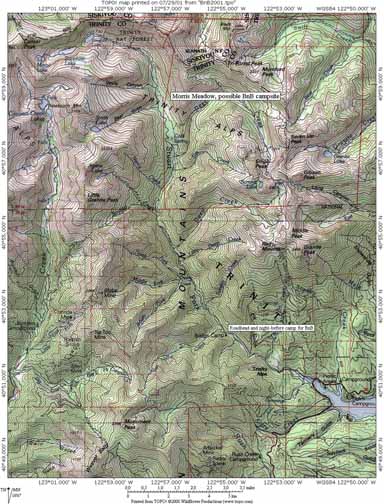
Topo map of the hike area
Take care,
Mike Diggles
Home: 154 Rutherford Ave., Redwood City, CA 94601-3511, (650) 369-6094
Work: U.S. Geological Survey, MS-951, 345 Middlefield Rd., Menlo Park, CA 94025. Phones: (800) 223-8081 x 5404 or (650) 329-5404 commercial. Fax: (650) 329-5453.
Boot 'n Blister Home Page on the Web
On the Web, the URL of this page is http://www.diggles.com/bnb/2001/BnB2001a.html
Date created: 07/29/2001
Last modified: 9/16/2005
Send e-mail to
Mike (mike@diggles.com)